ΠΕΡΑΜΑ
Το Πέραμα είναι δήμος στο δυτικό άκρο του Πειραιά. Συνορεύει βόρεια με το Χαϊδάρι και ανατολικά με το Κερατσίνι, ενώ η νότια πλευρά του βρέχεται από τον όρμο του Κερατσινίου και η δυτική από το Στενό της Σαλαμίνας. Το έδαφός του είναι βραχώδες, με το υψηλότερο σημείο να φτάνει τα 266 μ. στην κορυφή της Αγίας Τριάδας. Ιστορικά, η περιοχή ήταν γνωστή ως Αμφιάλη και συνδέεται με τον «Θρόνο του Ξέρξη», από όπου, σύμφωνα με την παράδοση, ο Πέρσης βασιλιάς παρακολούθησε τη Ναυμαχία της Σαλαμίνας το 480 π.Χ.
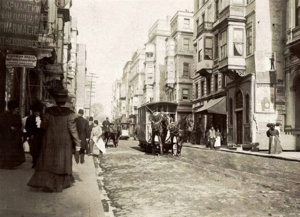
Το Πέραμα πήρε το όνομά του από μία από τις πιο ιστορικές και κοσμοπολίτικες συνοικίες της Κωνσταντινούπολης, το Πέρα. Από τον 19ο αιώνα έως τις αρχές του 20ού, το Πέρα αποτελούσε το ευρωπαϊκό κέντρο της πόλης, όπου συμβίωναν διαφορετικές εθνότητες και άνθιζαν το εμπόριο, ο πολιτισμός και η καλλιτεχνική ζωή. Η περίφημη Μεγάλη Οδός του Πέρα, η σημερινή Ιστικλάλ, περιβάλλεται από επιβλητικά κτίρια της Μπελ Επόκ, ιστορικές στοές, εκκλησίες και εμπορικά καταστήματα που μαρτυρούν το λαμπρό παρελθόν της περιοχής.
Στις αρχές του 20ού αιώνα, το Πέραμα ήταν ένα μικρό ψαροχώρι με ελάχιστους κατοίκους και αγαπημένος τόπος αναψυχής για τους Πειραιώτες και τους Αθηναίους. Μετά τη Μικρασιατική Καταστροφή γνώρισε ραγδαία ανάπτυξη, χάρη στην εγκατάσταση προσφύγων και στην εξέλιξη της ναυπηγικής δραστηριότητας. Το 1928 ιδρύθηκαν τα πρώτα ναυπηγεία, γεγονός που συνέβαλε καθοριστικά στην οικονομική ανάπτυξη της περιοχής. Το 1934 συστάθηκε η Κοινότητα Περάματος και το 1964 το Πέραμα αναγνωρίστηκε ως δήμος. Σήμερα αποτελεί μια πυκνοκατοικημένη περιοχή με σημαντική ναυπηγοεπισκευαστική παράδοση και ξεχωριστή θέση στην ιστορία του Πειραιά. Στην περιοχή μπορείτε να επισκεφθείτε το Μουσείο Ναυτικής Παράδοσης Περάματος και το Μουσείο Αλιείας και Ναυπηγικής.
[ΠΗΓΗ: www.perama.gr, www.travel.gr]
PERAMA
Perama is a municipality on the western edge of Piraeus. It borders Haidari to the north and Keratsini to the east, while its southern coast is washed by Keratsini Bay and its western coast by the Strait of Salamis. The terrain is rocky, with the highest point reaching 266 m at the summit of Agia Triada. Historically, the area was known as Amfiali and is associated with the “Throne of Xerxes,” from where, according to tradition, the Persian king watched the Battle of Salamis in 480 BC.
Perama takes its name from one of the most historic and cosmopolitan districts of Constantinople, Pera. From the 19th century until the early 20th century, Pera was the city’s European quarter, where diverse communities lived side by side and commerce, culture, and the arts flourished. Pera’s famous Grand Rue de Péra, now known as Istiklal Avenue, is lined with imposing Belle Époque buildings, historic arcades, churches, and shops that bear witness to the district’s glorious past.
In the early 20th century, Perama was a small fishing village with very few inhabitants and a popular leisure destination for the residents of Piraeus and Athens. Following the Asia Minor Catastrophe of 1922, it experienced rapid growth due to the settlement of refugees and the expansion of the shipbuilding industry. In 1928, the first shipyards were established, marking a turning point in the area’s economic development. In 1934, the Community of Perama was established, and in 1964, Perama was officially recognized as a municipality. Today, Perama is a densely populated area with a long-standing shipbuilding and ship repair tradition and a distinctive place in the history of Piraeus. Visitors can explore the Perama Maritime Heritage Museum and the Museum of Fishing and Shipbuilding.